-членом исполнительного комитета компании «Штуки», Швейцария.
(Перевод с английского)
Уважаемый П.Дроз!
1.Я рассказывал Вам, о том что в С-Петербурге в институте ЛМГП есть уникальный прибор – широкополосный георадар с глубинностью исследований до 70 и более метров. До такой глубины он может выделять неоднородности в грунте и трещины заполненные водой. И вот было бы хорошо в летний период отработать левый борт каньона на Усойском Завале и проследить, как вода подходит к родникам. Параллельно мы другими приборами измерили бы температуру и минерализацию воды в родниках и попробуем проследить более минерализованные воды с помощью электроразведки. Затем уже в зимний период со льда попробовать выделить трещины, по которым вода входит в тело завала на глубине. Сейчас эта группа находится в Рогуне. Я разговаривал с ними по телефону из Москвы. Руководитель группы согласен поработать на Сарезе, но для этого нужно очень оперативно решить финансовые и организационные и организационные вопросы. Так что сообщите реально это или нет.
2.Если вы планируете проводить дальнейшее исследования, то в будущем году целесообразно повторить гравиметрическую съемку на Усойском завале, причем несколько увеличить ее площадь. Гравиметрическая съемка выполнялась в 1976 году. За это время в теле завала могли пройти изменения и вот по сопоставлению результатов измерений можно выявить участки разуплотнения отложений завальной плотины.
3. На Правобережном склоне повторить часть сейсморазведочных профилей и выявить участки сжатия и растяжения оползня, установить более точно положение предполагаемой интрузии.
4. Потребность в геофизических исследованиях велика, а при строительстве ГЭС объем изысканий возрастет и состав их измениться. Потребуется Свой геофизический центр или партия, чтобы выполнить такие объемы работ.
С уважением Леонид. 14.09.2009.
Уважаемый Леонид!
Большое спасибо за письмо, на которое я отвечаю из Тегерана, поскольку я нахожусь там в командировке по поводу арочной плотины.
Прежде всего, я хотел бы сказать Вам, что я глубоко сожалею, что у нас не было возможности встретиться в 2000 году в начале реализации проекта по снижению риска для Сарезского озера (Lake Sarez Risk Mitigation project. Дело в том, что документы, которые Вы опубликовали, а мы использовали, были самыми ценными. У вас действительно хорошее понимание поведения плотины, хотя я не согласен с механизмом обрушения Правобережного склона.
Спасибо Вам за информацию, которую Вы даете. Наше внимание сейчас конкретно направлено на возможное снижение уровня воды в озере и, между прочим, возможное получение электроэнергии. Уровень воды необходимо снизить на 50 м.
Вот почему мы пытаемся исследовать район озера Шадау, особенно с целью узнать, что за обломочный материал покрывает устойчивую породу под водой. Другая задача – получить лучшее представление о перемычке (перешейке) между озерами Сарез и Шадау, какова глубина устойчивой породы?
К сожалению, наш интерес намного больше технический, чем научный.
Я буду информировать Вас о продвижении проекта и просить о консультациях, если таковые будут необходимы.
С уважением
П.Дроз. 23.09.2009.
Уважаемый П.Дроз!
Благодарю Вас за письмо. И хочу Вам рассказать историю сейсмических исследований Правобережного оползня. В 1975 году Заданием Министерства Геологии СССР изучение Правобережного оползня поручалось Ташкентскому институту ГИДРОИНГЕО. Геофизики этого института составили проект, но после рекогносцировки отказались его выполнять. Такое решение они мотивировали технической невозможностью выполнять сейсморазведочные измерения на таком крутом склоне. Тогда же эти исследования предложили провести институту САО Гидропроект и ряду других организаций, занимающихся инженерной геофизикой. Но организацию, которая взялась бы за выполнение этих работ, не нашли (Наша партия в то время была занята работами на Усойском завале). В 1977 году на Сарезе были проведены консультации с заведующим кафедры сейсмометрии и сейсмоакустики МГУ профессором А.В.Калининым, считавшимся в то время крупнейшим специалистом по инженерной сейсморазведке. Он также считал, что при имеющейся аппаратуре и при применявшейся методике работ выполнить эти работы невозможно. Группа А.В.Калинина в то время проводила в озерах Сарезское и Шадау водную сейсморазведку на участках порталов проектируемых туннелей. Работы очень интересные. Но непосредственно на измерения они проводили всего семь дней. Эту группу командировали на Сарез на один месяц. Остальное время у них ушло на организацию, установку, сборку и разборку аппаратуры.
Наша Памирская Гидрогеофизическая партия Южной геофизической экспедиции производила геофизические работы на договорной основе по заказам геологических организаций, в том числе и Южной гидрогеологической экспедиции, в которой работали В.В.Лим, Ю.М. Казаков, Ю.Акдодов и с ними сотрудничал В.С.Федоренко. В 1980 году ко мне обратился главный инженер п.о. Таджикгеологии Н.С.Огнев с предложением выполнить сейсморазведку на Правобережном оползне хотя бы по одному профилю. К этому времени я разработал и опробовал методику непродольных систем наблюдений в сейсморазведке МПВ для изучения высокогорных долин Памира и Дарваза и опробовал ее на хорошо изученных бурением и другими геофизическими методами участках. На семинаре по инженерной геофизике, который проходил на турбазе Пассанаури в Грузии в 1979 году, я сделал доклад о применении непродольных систем наблюдений в высокогорных условиях, который был одобрен участниками этого семинара. Но проблема была в том, что мы проводили измерения на аналоговой накопительной станции СМОВ-0-24 с применением накладных взрывов. Но в условиях крутого рельефа Правобережного участка проводить взрывы было опасно. Переносить на себе оборудование и большое количество взрывчатки было очень трудно. Поэтому я сообщил Н.С.Огневу, что выполнить такие работы ,в принципе, возможно. Но для этого, мою партию нужно обеспечить портативными накопительными сейсмостанциями СНЦ-1 (эта станция была разработана в институте Казгеофизприбор. Опытные экземпляры этой станции были уже изготовлены и проходили производственные испытания) и дать партии два года на подготовку персонала и освоение станции. СНЦ-1 позволяла заменить взрывы многократным возбуждением сейсмических колебаний ударами лома. Это был момент, когда разработка Казгеофизприбора на какое-то время обогнала портативные сейсмостанции американской фирмы «Бизон» аналогичного назначения.
Станции мы получили и нам поступил заказ на выполнение сейсмических и электроразведочных работ на участках Правобережный, Левобережный и Гудара в 1981-1984 годах. Сейсморазведочные работы на профиле 2 участка Правобережный были начаты в 1983 году, а закончены в 1984-м. За это время мы отработали один профиль 2, длиной 2600 метров. В марте 1985 года на Сарез вылетела специальная комиссия в которую входили руководители Таджикгеологии, руководители ЮГГЭ как заказчики работ и я, как их ответственный исполнитель. Я показал им на местности точку, в которой в 1986 году пробурили скважину. Но тогда руководители ЮГГЭ категорически отказались бурить скважину. Другого более подходящего и безопасного места они найти не могли. Поэтому комиссия приняла такое решение: бурение скважины перенести на 1986 год, а 1985 году продолжить сейсморазведочные работы. Был написан новый проект на 1985-1987 годы. Этот проект предусматривал детальные работы на Правобережном, сквозной профиль, пересекающий долину реки Мургаб с правого берега на левый (через озеро). По этому профилю необходимо было проследить коренное ложе долины (кровлю монолитных пород). Кроме этого предусматривалось закончить геофизические работы на Усойском завале, начатые в 1975-76 годах.
В 1985 году на Правобережном склоне было отработано еще шесть профилей. Причем работы продолжались до начала декабря м-ца, а затем наша команда попала в снежный плен и смогла вылететь с перемычки между озерами, только 30 декабря. В январе 1986 года проект проходил экспертизу в отделе гидрологических работ МинГео СССР и все невыполненные в 1985 году объемы геофизических работ исключили из проекта, мотивируя это тем, что такие работы должны проводить организации Минводхоза.
В 1986 году работ на Сарезе у нас не было. Мы находились на другом, еще более труднодоступном участке Ак-Джилга. С Сареза нам сообщали, что бурение скважины идет очень медленно. Я постоянно напоминал ЮГГЭ, что в скважине нужно сделать сейсмические исследования, чтобы увязать положение преломляющих границ и поверхностей смещения. Но денег на эти работы так и не выделили. Больше того, по проекту предусматривалось бурение 2-х скважин. Первая по вертикали, вторая по нормали к дневной поверхности. Мотивируя тем, что фактические затраты на бурение вертикальной скважины значительно превышают сметные руководство ЮГГЭ решили вторую скважину не бурить. С выводами В.С.Федоренко и геологов ЮГГЭ о положении поверхности скольжения я сразу был не согласен. К тому же никаких консультаций и обсуждений они с нами не проводили. По оценке специалистов геофизиков выполнения сейсморазведки на таком склоне является выдающим техническим достижением того времени. Потом, когда я начал работать в Москве многие специалисты по сейсморазведке не верили, что такие работы удалось провести.
С 1986 года мы начали категорически отказываться от договорных работ с ЮГГЭ. Дополнительную обработку материалов перед сдачей отчета проводить не стали и в конце 1986 или начале 1977 года вручили им предварительный отчет, как окончательный. Руководство ЮГФЭ нас поддерживало, так как было много заказов на рудных объектах, которые экспедиция не успевала выполнять. И отрывать лучших исполнителей и дорогостоящую технику на сложные и опасные работы, которые Заказчик организовал безграмотно, да еще и не может гарантировать никаких перспектив, они категорически не хотели. В 1989 году к нам обратился Московский институт «Созгипровохоз» с предложением провести большой объем геофизических исследований на Усойском завале, в долине реки Бартанг от завала до кишлака Барчадив. Исследования берегов озера мы попросили перенести на следующий проект, т.к. для выполнения этого объема работ силами всей нашей партии понадобилась два года. Поэтому во второй половине 1989 года мы согласились с предложением ЮГГЭ провести геофизические работы на четырех небольших участках в верхней части озера для подготовки к выполнению работ по заказу Союзгипроводхоза. В феврале 1990 года мы должны были начать изучение верхнего бьефа Усойского зовала со льда Сарезского озера. Но из-за беспорядков в Душанбе мы смогли отправить свой отряд только в первых числах марта. Исследования шли успешно до 15 апреля 1990 года. И где-то в это время Союзгипровохоз известил нас о том, что из-за сложного положения в Таджикистане проект закрывается. И нам пришлось вывозить людей и аппаратуру за счет ЮГФЭ, а остальное оборудование просто оставить.
Все оползни правого берега реки Мургаб от Барчадива до Казанкуль смещаются по кровле монолитных гидротермально измененных пород. Это, не зная результатов геофизических работ, утверждали геологи: В.Е.Верхотуров, Ш.Ш.Деникаев, В.Н.Минаев. Обусловлено это тем, что они находятся в зоне эндо и экзоконтакта интрузии.
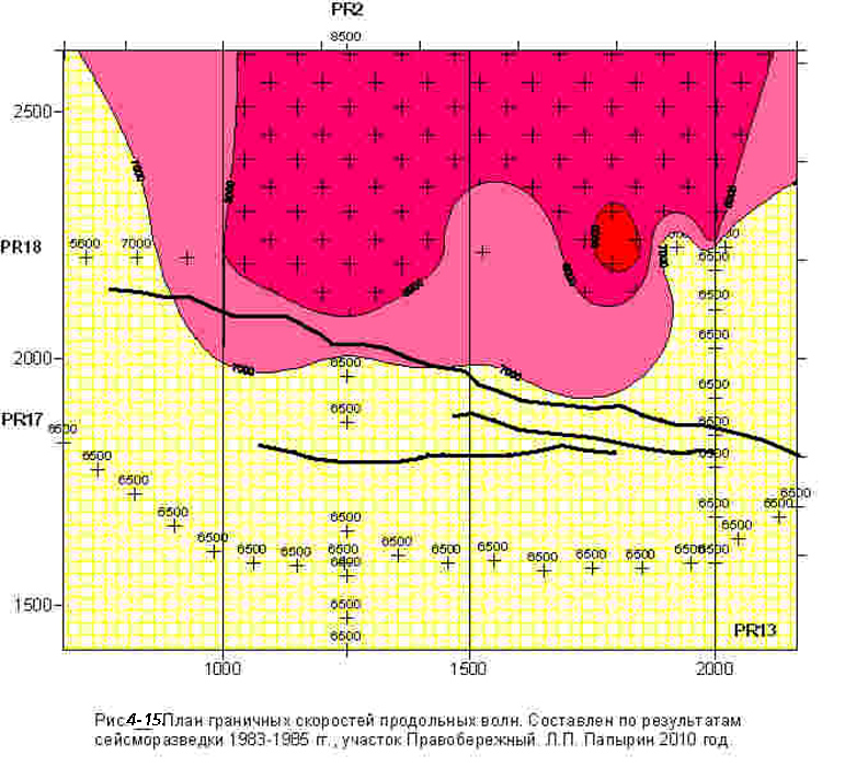
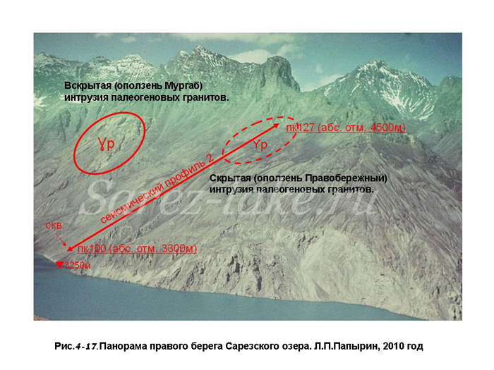
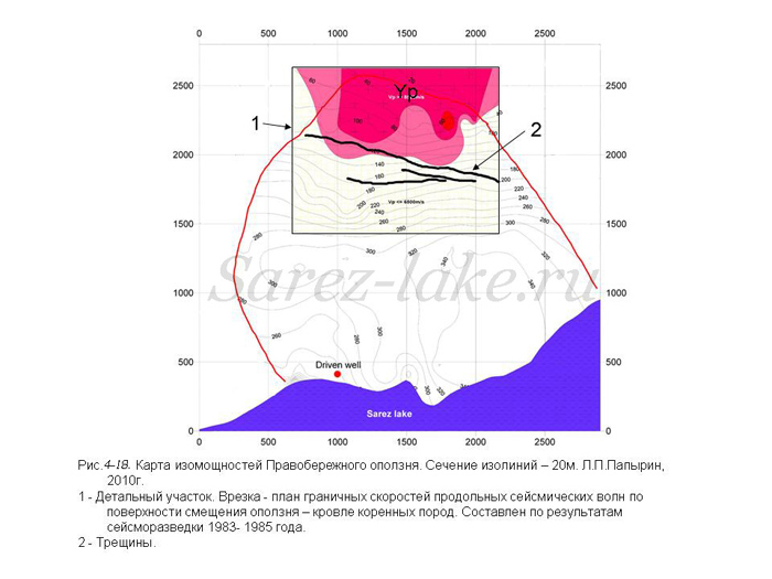
Как и на Усойском завале, кровля монолитных пород, на Правобережном участке, фиксируется преломляющей границей, с граничной скоростью 6500 м/сек. В верхней части Правобережного оползня (выше известных трещин) граничная скорость достигает 8000-8500 м/сек. Таким значительным увеличением скорости продольных волн фиксируется апофиза, пока не вскрытой, интрузии палеогеновых гранитов, более молодой по сравнению с породами Сарезской свиты. Такая же интрузия находится в центре ниши оползня Мургаб к северу- северо-западу от Правобережного оползня. Ее выход на дневную поверхность хорошо виден с Правобережного оползня, с левого берега озера и Усойского завала.
Во всех построениях глобальной тектоники исследуемый район представляется зоной столкновения двух крупнейших литосферных плит – Индийской и Евразиатской. Не вдаваясь в детали глубинного строения и тектонических особенностей этого региона, следует отметить, что именно это обстоятельство обусловило высокую сейсмическую активность, которая привела к формированию большого количества грандиозных оползней. Из представленных сейсмологических данных ясно, что в западной части Сарезского озера пересекаются два крупных глубинных региональных тектонических нарушения (на глубине 100-200 км) или два сейсмических шва (по Г.А.Гамбурцеву).
В районе их пересечения находятся грандиозные оползни: Усойский, Мургаб, Правобережный, Ирхтский Повышенная сейсмическая активность способствовала формированию поверхностей их смещения. Механизм этого влияния заключается в следующем. При глубинном сейсмическом толчке упругие колебания по монолитным породам апофизы интрузии достигают верхних частей разреза быстрей чем по вмещающим породам. На контакте гранитов и вмещающих пород выделяется энергия, которая идет на разрушение вмещающих пород в зоне контакта. После частичного их разрушения и снижения скоростей этот процесс ускоряется. Это приводит к тому, что в районе еще не вскрытой интрузии начинает формироваться грандиозный оползень. Вероятнее всего, размеры и морфология интрузии определяют параметры подготовленных ими оползней. Анализ имеющихся геодезических данных, также говорит о том, что оползень смещается по поверхности близкой к поверхности кровли коренных пород, а не по поверхностным слоям, как голословно утверждают работники ТИСССА. Хотя есть немало методов с помощью которых можно доказать, что смещение идет по поверхностным слоям. И не понятно почему они ими не воспользуются.
Правобережный оползень развивается под действием постоянных относительно слабых сейсмических толчков, фиксируемых только чувствительной сейсмологической аппаратурой. Средняя мощность Правобережного оползня – 250 м, площадь – 5 км2, объем 1,25 км3 и об этом мы сообщили еще в 1985 году. Интрузия, вызвающиее развитие правобережного оползня находится гипсометрически выше верхней трещины. Мощность, перекрывающих разрушенных пород, колеблется в пределах 30-60 метров. Ниже интрузии (по склону) находится ослабленная трещеноватая зона (с пониженным значением сейсмических скоростей), в пределах которой и находятся , выявленные в 1967 году трещины. В средней части склона значение Vp вновь повышается. Такая же картина отмечается на интрузии в центре оползня Мургаб. Там выход палеогеновых гранитов окружен кольцеобразной трещиноватой зоной, а микротрещины имеют радиальное направление. Так что наличие Правобережного оползня это факт. Мне все это было известно еще 30 лет назад. Но я внимательно следил за публикациями работников ТИСССА (А.Р. Ищук, Н.Р. Ищук и тем более С.С.Негматуллаев). За тридцать лет они не смогли найти ни одного обоснованного доказательства, доказывающего отсутствие оползня.
Я думаю, что если вы в спокойной обстановке познакомитесь со всеми материалами, то согласитесь с моим утверждением.
К тому же я разработал способ трансформации грандиозного оползня в крупнообломочную осыпь и получил на него патент. Смещением крупнообломочной осыпи в озеро не вызовет высокой волны.
При наличии финансирования я могу построить томографических моделей 3D Усойского завала (по гравиметровой съемке) и Правобережного оползня (по сейсморазведке). Наличие этих моделей сделает результаты исследований более наглядными и понятными.
Во время нашего разговора в Нуреке, я, по-моему, говорил вам, что некоторые виды исследований целесообразно проводить в зимний период со льда озера. Так трещины на верхнем бьефе, где втекает вода целесообразно найти со льда с помощью ЭМИ СШП зондирования. Оптимальное время работы март-апрель. Но нужна серьезная подготовка и время вроде уже упущено. Глубинность исследований 70-100м. Аналогов такой аппаратуры в мире нет. С помощью такой аппаратуры в туннелях Рогунской ГЭС исследовали участки вывалов. Основной специалст по этому методу – уроженец Душанбе В.Н.Ильяхин. В летний период можно проследить пути по которым вода идет к родникам. С помощью этой же аппаратуры можно конфигурацию и глубину трещин на Правобережном оползне.
Все виды геологических работ в соответствии с инструктивными требованиями должны проводиться после опережающих геофизических работ. Все квалифицированные геофизики из Душанбе уже давно уехали. Работники ТИСССА (А.Р. Ищук, Н.Р. Ищук и тем более С.С.Негматуллаев) на Сарезе никогда не работали, тем более они не геофизики, да организационно-изыскательских работ никогда не проводили. Если ваши мечты о строительстве ГЭС и приведении Сарезского озера в безопасное состояние еще не изчезли, то нужно провести большой объем очень сложных и дорогостоящих геофизических исследований. Нужно готовить проект, аппаратуру, сотрудников и т.д. и т.д. Все это мне очень знакомо, так как я 27 лет проработал на Памире начальником партии (ответственным исполнителем геофизических работ). А в последние годы изучил новое для себя дело – способы исследования качества бетона и бетонных конструкций. Это очень пригодится уже в процессе строительства.
Способы организации геофизических работ могут быть разные. Если Вы начнете организацию своей группы и приобретете, необходимую дорогостоящую аппаратуру и пригласите специалистов с высокой зарплатой, то из-за малой продолжительности сезонов, вы не сможете занять их постоянно и работой. И будете нести постоянные убытки. Можно заключить на продолжительный срок договор с нашей организацией о проведении геофизических исследований. В этом случае мы смогли бы заключать договора и с другими организациями и более эффективно использовать аппаратуру и специалистов. В условиях Москвы при необходимости мы могли бы арендовать аппаратуру и специалистов на короткий срок. К тому же я поддерживаю связь со своими бывшими коллегами и учениками, которые за это время стали первоклассными специалистами-геофизиками. При необходимости я смог бы приглашать их на работу на короткое время. При этом нужно учесть, что это не просто квалифицированные геофизики, а специалисты имеющие опыт работы в Таджикистане 10-15 лет.
Когда-то и в Таджикистане создали организацию, которая монопольно и круглогодично занималась инженерной геофизикой на самом современном уровне. Я был организатором и начальником этой партии. У нас не было никаких проблем с аппаратурой, оборудованием, специалистами. Я побывал на всех конференциях и семинарах по инженерной геофизике. И то полностью мы отладили все виды работ за несколько лет. Но сейчас в Таджикистане специалистов нет. Из-за клановых противоречий пригласить специалиста с высокой зарплатой они не захотят. Такой специалист не должен зависеть от их клановых привычек, иначе никаких результатов работ не будет. Поэтому у меня убедительная просьба определиться с задачами геофизических исследований, финансами и степенью моего участия. Самый лучший вариант составить проект и организовать геофизическую группу в нашей организации «Мосгиросталь», а для работы привлекать как московских специалистов, так и Таджикских из Южной геофизической экспедиции.
Посол ОБСЕ в Душанбе В.Ф.Пряхин предлагал мою кандидатуру экспертом Всемирного банка по Сарезу и по Рогунской ГЭС. Но как только срок его пребывания в Таджикистане закончился, про это сразу забыли. Поэтому убедительно прошу с помощью ваших связей помочь мне в решении этих вопросов. Тогда мне было бы проще составить свои планы в на будущее.
Поздравляю Вас с праздником Нового Года, желаю здоровья, успехов работе. Успехов и удачи во всех делах. Леонид. 28.12.2009.
Уважаемый Леонид!
Большое спасибо за ваш анализ и предложения. Мы их изучим и сообщим наше мнение очень скоро.
С уважением
П.Дроз. 12.01.2010.
Уважаемый П.Дроз!
Благодарю Вас за ответ на мое письмо. С нетерпением жду Ваших комментариев относительно результатов сейсморазведки на Правобережном оползне, описанных в прошлом письме.
Я прочитал в WWW, что Ваша фирма STUCKY в конце мая начале июля текущего года участвует в Тендере по выбору компаний для экологической экспертизы и составления ТЭО на строительство Рогунской ГЭС. В 2005-2010 годах я занимался материалами по Рогунгской ГЭС, последовательно работая в Русской инженеринговой компании (Русал), в ООО «Рогун-Сервис», СПКТБ(специальное проектро-конструкторское технологическое бюро) « Мосгидросталь» в качестве главного специалиста по геофизическим методам отдела инженерных технических изысканий. Я занимался анализом инженерно-геофизических и сейсмологических материалов изысканий на Рогунской ГЭС за период с 1968 по 2006 год. Составлением технических заданий для исследования строительных туннелей Рогунской ГЭС геофизическими методами: ЭМИ СШП (электромагнитное импульсное сверхширокополосное) георадарного зондирование, сейсморазведка МПВ (методом преломленных волн), ультразвуковые измерения, электроразведочные работы ЭП (электропрофилирование) и ЕП (естественного электрического поля), регистрация поля ЕЭМИ (Естественное электромагнитное импульсное поле) – определение границ и геометрических размеров вывалов кровли; оценка упругих и деформационных характеристик основных типов грунтов, вмещающие исследуемые выработки; определение состояния и прочностных характеристик бетона облицовки и конструкций порталов; определение толщины бетонной обделки и наличия пустот в обделке и за обделочном пространстве по всей длине обследуемых туннелей. Поэтому я предлагаю Вам дать мне грант на обобщение и изложением инженерных геофизических материалов по Рогуну или включить меня в состав экспертов.
В сентябре-октябре прошлого года при моем посредничестве Главное управление Геологии РТ и геофизический отдел Рогунской ГЭС приобрели портативную геофизическую аппаратуру Шведской компании ABEM (Шведское сокращение, которое в Европе все знают. Как имя собственное) Instrument AB. Обе эти организации прислали мне письма с просьбой оказать им методическую помощь, но, по-видимому, их финансовые затруднения не позволили это сделать. Я думаю, что полученной аппаратуры явно недостаточно, да предназначена она для работы на дневной поверхности. По моим представлениям для того, чтобы однозначно ответить на все вопросы для окончательного заключения о возможности строительства Рогунской ГЭС там должна работать большая, укомплектованная современной аппаратурой группа квалифицированных геофизиков 1,5-2 года.
О геофизических исследованиях, которые нужно провести на Сарезе я уже писал Вам в прошлом письме. Поэтому пока мое здоровье и физическая подготовка позволяют работать в поле, то я готов 2-3 года руководить геофизическими исследованиями на Сарезе. Подготовка к выполнению летних работ продлится 1,5-2,0 месяца. Из-за того, то вопрос еще не решен и подготовка еще не началась, реально в этом году там можно проработать с начала августа до половины октября.
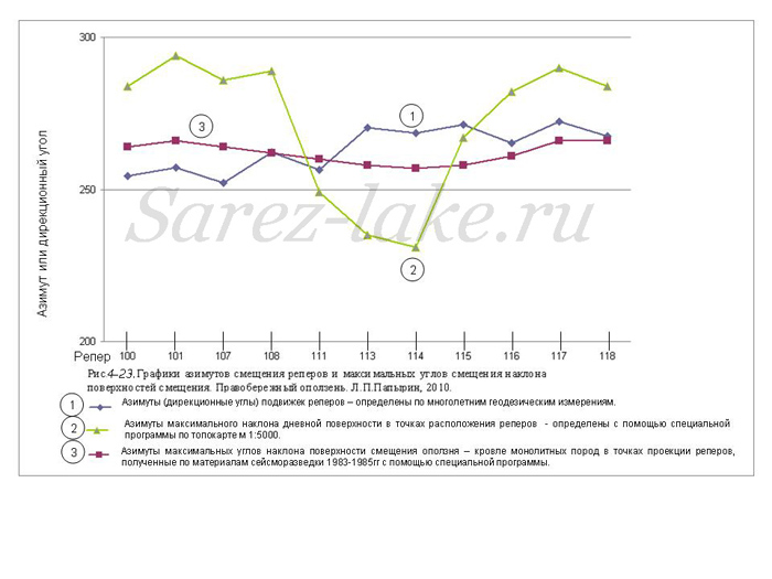
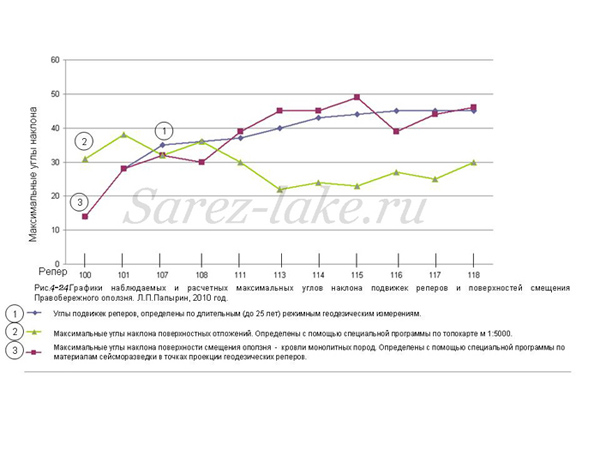
Посылаю Вам несколько рисунков, иллюстрирующих положение еще не вскрытой апофизы интрузии палеогеновых гранитов. Эта апофиза прорвала более древние породы Сарезской свиты и явилась основной причиной возникновения Правобережного оползня. Обратите внимание на графики максимальных углов наклона и их азимутов на поверхности смещения оползня – кровли плотных пород. Они вполне удовлетворительно совпадают с результатами геодезических измерений на поверхностных геодезических реперах, а не с поверхностными отложениями. Если бы смещались поверхностные отложения, то в районе скважины наблюдалась деформация грунта или искривление обсадной трубы в верхней ее части. В 2006 году я лично осмотрел трубу и площадку и никакой деформации не заметил. Между тем за период с 1986 по 2006 год по ближайшим реперам отмечено горизонтальное смещение в 2 м. При таком смещении осадную трубу сорвало бы по плоскости смещения или хотя бы значительно деформировало.
Ледниковые отложения на склоне есть, но мощность их незначительна. Они хорошо выделяются пониженными значениями скоростей преломленных волн. Их подошва легко без каких-либо технических проблем и усилий определяется сейсморазведкой. И для нас не представляло труда ее проследить с любой степенью детальности, но такая задача перед нами не ставилась. К тому же на этом участке не успели сделать куда более актуальные дела, например, детальное прослеживание апофизы интрузии выше нашего профиля 18.. Так что общий объем Правобережного 1,25 км3, а может быть и больше. Строение оползня и динамика его будущего движения такая же, как на Усойском и Мургабском оползнях.
С уважением, Леонид. 01.03.2010.
Dear Patrice!
Hope you are fine. It was a real pleasure to talk to you in Nurek.
Further to our talk I would like to let you know about the following.
As I have told you, there is a unique device in the St. Petersburg LMGP Institute – a broadband georadar with the depth of the research up to 70 meters. This is the depth to which it can distinguish heterogeneities in the ground and cracks filled with water. It could be very useful to work out the left side of the Usoi dam using this device at the summer period and trace the water feeding the springs.
Simultaneously we could measure the water temperature and mineralization in the springs and try to trace more mineralized waters with the help of the electrical exploration. Then, at the winter period, from the ice surface we could try to distinguish the cracks, that allow water to come into the body of a dam.
The group of scientists that can do that work are now in Rogun. I had a telephone talk with them from Moscow. The group manager agreed to work at Sarez, but some financial and organizational issues need to be solved in a short time. Could you be so kind to tell me if this is real or not?
If you plan further researches, it is rational to make a gravimetric survey of the Usoi dam again in a larger area. The last gravimetric survey was made in 1976. There could be changes in the body of a dam since that time. It is possible to detect decompressed areas of the sediments of a dam by comparing the results of the surveys.
On my opinion it is rational to make again some of the seismological exploration profiles. It is neсessary to detect more precisely compressed and decompressed areas of the dam and locate the supposed intrusion.
There is a high demand for the geophysical researches now and during the building of the hydro-power plant the volume and the structure of work could possibly changed and increased. That will be a need in a separate Geophysical Centre to carry out the researches.
Looking forward to hearing your thoughts on the above,
Kind regards, Leonid Papyrin. 14.09.2009.
Dear Leonid,
Many thanks for your message to which I answer from Tehran since I am on mission there for an arch dam.
First of all, I would like to tell you that I deeply regret that we did not have the opportunity to meet in 2000, at the beginning of the Lake Sarez Risk Mitigation project. The fact is that the documents you have published and we used were the most valuable of all. You really had a good understanding of the behavior of the dam, although I do not agree with you on the mechanism of failure of the Right Bank Slope.
Thank you for the information you give. Our concern now is specifically oriented to a possible reduction of the lake level and by the way, a possible power generation. The level of the lake should be lowered by 50 m. This is why we are trying to investigate in the area of Lake Shadau especially in order to know what is the debris cover above the sound rock, under water. Another issue is to have a better idea of what the isthmus between Sarez and Shadau, how deep is the sound rock? Unfortunately, our concern is much less scientific than technical. I will let you inform on the progress of the project, and will not hesitate to ask you consulting services if needed.
Best wishes, Patrice DROZ. 23.09.2009.
To: Patrice DROZ
Member of the Executive Board
STUCKY Ltd
Rue du Lac 33, Case postale
CH – 1020 Renens VD 1 / Switzerland
Thank you very much for your letter. In reply, I would like to tell you the history of the seismic investigations of the Right Bank Landslide. In 1975 by the Task of the Ministry of Geology of the USSR, the study of the Right Bank Landslide was entrusted to the Tashkent HYDROINGEO Institute. Geophysicists from this Institute have prepared a project, but after the reconnaissance they refused to implement it. Their motivation of such a decision was the technical impossibility to carry out seismo-exploratory investigations on such a steep slope. At the same time these investigations were offered for implementation to the SAO HYDROPROJECT Institute and a number of other organizations dealing with engineering geophysics. However, an organization which would do these works was not found (Our team was busy working at the Usoi Dam at that time). In 1977 the consultations on the Sarez area were conducted with Professor A.V. Kalinin, Head of the Chair on Seismometry and Seismic Acoustics of the Moscow State University, who was considered at that time as the greatest specialist in engineering seismic exploration. Professor A.V.Kalinin had the same opinion that with the existing equipment and techniques used at that time it was impossible to implement these investigations. The team of A.V.Kalinin was carrying out at that time seismic explorations of water in Lakes Sarez and Shadau in the areas of portals of the projected tunnels. The works were very interesting, but they included only seven days directly for measurements. This team was forwarded to work at the Sarez area for a month. The rest time was spent for organization, installation, assembling and disassembling of the equipment.
Our Pamir Hydrogeophysical team of the Southern Geophysical Expedition (SGE) was carrying out geophysical works on the agreement basis by the orders of geological organizations, including also the Southern Geophysical Expedition, where V.V.Lim, Yu.M. Kazakov and Yu. Akdodov worked in cooperation with V.S. Fedorenko. In 1980 Mr. N.S. Ognev – Chief Engineer of the “Tajikgeologia” Organization – addressed to me with a suggestion to carry out seismo-exploratory survey at the Right Bank Landslide, at least for one profile. By that time I had developed the method of non-longitudinal observation systems for seismic explorations of MLW for studying the highland valleys of Pamir and Darvaz and tested it in the sites well studied by drilling and other geophysical methods. In 1979 at the Workshop on Engineering Geophysics held at the tourist hostel “Passanauri” in Georgia I made a report on application of non-longitudinal observation systems in Alpine conditions, which was approved by the participants of this Workshop. But the problem was in that we were carrying out measurements on the analog accumulating station SMOV-0-24 with the use of overlain explosions. To carry out explosions in conditions of the steep relief of the Right Bank Landslide was dangerous. To carry equipment and a great amount of explosives by hand was very difficult. Therefore, I informed Mr. N.S.Ognev that to implement such works is, in principle, possible, but in this case my workers should be supplied with portable accumulating seismic stations SNC-1 (this type of stations was developed at the “Kazgeophyspribor” Institute; experimental patterns of the station were already manufactured and experienced pilot testing) and given two years for training and preparation for working on the station. The station SNC-1 enabled us to replace explosions by multiple excitation of seismic oscillations by means of crow’s blows. It was the moment when the development of the “Kazgeophyspribor” Institute left behind for some time the analogous-purpose portable seismic stations of the American Firm “Bizon”.
So, we have got the stations and then an order for carrying out seismic and electro-exploratory works in the areas of the Right and Left Banks and Gudar for the period of 1981-1984. Seismic explorations on Profile 2 of the Right Bank area were started in 1983 and finished in 1984. During this period we explored Profile 2 of 2600 m long. In March of 1985 a special commission came to Sarez. The commission included the officials of the “Tajikgeologia” Organization and Southern Geophysical Expedition (SGE) as the Clients and me as a Managing Executor of the works. I showed them the place where in 1986 a well was drilled. But at that time the SGE officials categorically refused to drill a well there. But they could not find another, more suitable and safe place for drilling. Therefore, the Commission took the decision to postpone the drilling of a well to the year 1986, and in 1985 to continue seismic explorations. A new project for 1985-1987 was prepared. This project envisaged detailed investigations on the Right Bank slope, a through profile crossing the Murgab River valley from the right-hand shore to the left-hand one (across the lake). This profile would be used to watch the base floor of the valley (roof of the monolithic rocks). Besides, it was planned to complete the geophysical works at the Usoi Dam, started in 1975-1976.
In 1985 the next six profiles were investigated on the Right Bank Slope. The investigations continued till the beginning of December; then our team was taken into the snow “captivity” and could leave the coffer-dam between two lakes only on the 30th December. In January 1986 the project was under expertise at the Hydrology Department of the Ministry of Geology of the USSR, after which the geophysical works, which were not finished in 1985, were removed from the project with the motivation that such works should be carried out by the organizations of Ministry of Water Management.
In 1986 we had no works in the Sarez area. We were working at that time in another, more difficult-accessible area Ak-Djilga. We were informed that in the Sarez area the well drilling was progressing very slowly. I advised constantly to SGE to make seismic investigations in the well in order to coordinate the position of reflecting boundaries with the surfaces of displacement. But no funds were given for these works. Moreover, it was planned within the project to drill two wells: one – along the vertical, the second – along the normal to the day surface. Motivating that the factual expenses for drilling a vertical well considerably exceed the estimated cost, the SGE Administration decided not to drill the second well. I was not agreed at once with the conclusions of V.S. Fedorenko and geologists from SGE about the position of the sliding surface. By the way, they did not make any consultations and discussions with us. By estimates of the geophysical specialists, carrying out seismic explorations on such a steep slope was an outstanding engineering achievement of that time. Later, when I began working in Moscow, many specialists in the field of seismic explorations did not believe that it was managed to implement such works.
Since 1986 we began categorically refuse from the works by agreement with SGE. Without additional treatment of the informational material before presenting the report, we presented to SGE in the end of 1986 or beginning of 1988 the preliminary report as the final one. The Administration of SGE supported us, as there were many orders for works at the ore-producing enterprises and the Expedition had no time to implement them. It was not reasonable for the Expedition to prevent its best workers from working at the own enterprises and use them and expensive equipment for complicated and dangerous works, which were organized by the Client improperly and without guarantee of any prospects for future. In 1989 the Moscow Institute “Soyzgiprovodkhoz” addressed to us with a proposal to carry out a large amount of geophysical investigations at the Usoi Dam in the Bartang River valley, in the area stretching from the dam to kishlak (village) Barchadiv. As to implement this amount of works would require for our team two years, we asked to postpone investigations of the lake shores to a next project. Therefore, in the second half of 1989 we agreed with the proposal of SGE to carry out geophysical investigations in four small areas in the upper part of the lake, in order to prepare ourselves for carrying out the works by the order of the Moscow Institute “Soyzgiprovodkhoz”. In February 1990 we had to start studying the head water of the Usoi Dam from Lake Sarez ice. Due to the disturbances in Dushanbe we could start investigations only in the first days of March. The investigations were successful till 15 April 1990. And somewhen in that time the Institute “Soyzgiprovodkhoz” informed us that due to the difficult situation in Tajikistan the project should be closed. So, we had to take off the people and some equipment at the expense of SGE and the rest equipment simple to leave.
All the landslides of the right-hand shore of River Murgab from Barchadiv to Kazankul were moving along the roof of monolithic hydrothermally changed rocks. This was stated by the geologists V.E. Verkhoturov, Sh.Sh. Denikaev, V.N.Minaev, who did not know the results of the geophysical investigations. The reason for this statement was that the rocks were situated in the zone of endo- and exo-contact of intrusion.
Like under the Usoi Dam, the roof of monolithic rocks on the Right Bank slope is fixed by the refracting boundary with a limit velocity of 6500 m/sec. In the top part of the Right Bank Landslide (above the known cracks) the limit velocity reached 8000-8500 m/sec. Most probably, such a considerable increase in the velocity of longitudinal waves pointed to the apophisis of unoutcropped intrusion of paleogenic granites, more younger as compared with the rocks of the Sarez formation. The same intrusion exists in the center of the Murgab landslide niche to the north – north-west from the Right Bank landslide. Its exposure to the day surface is well seen from the Right Bank landslide, left-hand shore of the lake and Usoi Dam.
In all the constructions of the global tectonics the region under study is presented as a zone of two largest colliding lithospheric plates – Indian and Eurasian. Not touching the details of the deep structure and tectonic features of this region, it should be noted that just this circumstance determined the high seismic activity, which led to formation of a large number of tremendous landslides. The seismological data show that in the western part of Lake Sarez two large deep regional tectonic disturbances (at a depth of 100-200 km) or two seismic joints are intersected (after G.A. Gamburtsev).
There are tremendous landslides in the area of the above intersection: the landslides of Usoi, Murgab, Right Bank and Irhtsky. Formation of their sliding surfaces was stimulated by influence of the increased seismic activity. The mechanism of this influence is in the following. While a deep seismic tremor, elastic oscillations along monolithic rocks of the intrusion apophysis reach the upper part of the cross-section quicker than along water-enclosing rocks. At the contact of granites and water-enclosing rocks energy is emitted and begins to destruct the water-enclosing rocks in the contact zone. After partial destruction of them and decrease of velocity, this process is accelerating. This leads to formation of a large landslide in the area of unexposed (yet) intrusion. Probably, sizes and morphology of intrusion determine the parameters of landslides prepared by them. Analysis of the existing geodetic data also indicate that the landslide is displacing rather along the surface close to the surface of the base rocks roof than along the surface layers, like the people from ТИСССА? state. Although there are many methods, by means of which one would prove that the displacement occurs along the surface layers. And it is not understandable why they are not used.
The Right Bank Landslide is developing under the action of constant, relatively weak seismic tremors that are registered only by sensitive seismological devices. The average thickness of the Right Bank Landslide is 250 m, the area is 5 km2, the volume is 1.25 km3, and we have informed about this already in 1985. Intrusion, which causes the development of the Right Bank Landslide, occurs hypsometrically above the upper crack. The thickness of the overlying destructed rocks varies within 30-60 m. Beneath the intrusion (along the slope) there is a weakened fissured zone (with low seismic velocities), within which there are the cracks revealed in 1967. In the middle part of the slope the Vp-value again increases. The same picture is observed in the intrusion zone in the center of the landslide Murgab. There, the outcropped paleogenic granites are rounded by a ring-shaped fissured zone with micro-cracks having a radial direction. Thus, the availability of Right Bank Landslide is a fact. I knew this already 30 years ago. But I was watching attentively the publications of specialists from ТИСССА (A.R. Ishchuk, N.R. Ishchuk and, moreover, S.S. Negmatullaev). During 30 years they could not find any grounded proof which would confirm the absence of the landslide.
I think that if you will carefully and in a calm situation familiarize yourself with all the materials, you agree with my statement. Besides, I have developed and patented a method for transformation of a large landslide into large-fragmented debris. Displacement of such debris into the lake cannot cause a high wave.
If to have funds, I could construct tomographic 3D-models of the Usoi Dam (by gravimetric survey) and Right Bank Landslide (by seismic exploration). These models would make results of the investigations more vivid and understandable.
During our talk in Nurek I have told that it is reasonable to carry out some types of investigations in winter period from the lake ice. To reveal cracks in the high water area, where water inflows, from the ice is reasonable with the use of ЭМИ СШП – sounding. The optimal time for works is March-April. But these works need a serious preparation, and the time for the preparation is, perhaps, already missed. The depth of investigations is 70-100 m. Analogs of such equipment do not exist in the world. Such equipment was used to investigate the dumps in the tunnels of the Rogun Hydro-electrical plant (HEP). The basic specialist in using this method is Mr. V.N. Iliyakhin born in Dushanbe. In summer period one can watch the channels, along which water flows to the springs. The same equipment can be used to determine the configuration and depth of cracks on the Right Bank Landslide.
All the types of geological investigations should be carried out in accordance with the instructive requirements after the ahead-conducted geophysical works. All the qualified geophysicists have long left Dushanbe. The specialists from ТИСССА (A.R. Ishchuk, N.R. Ishchuk and, moreover, S.S. Negmatullaev) never worked in the Sarez area; moreover, they are not geophysicists and never conducted organizational and exploratory works.
If your dreams to build a hydro-electrical plant and set the Lake Sarez into the safe state did not disappear yet, then it is necessary to carry out a large amount of very complicated and expensive geophysical investigations. It is necessary to prepare a project, equipment, specialists and so on. All this is very familiar to me, as I have worked during 27 years on Pamir as a field-team head (a managing executor of geophysical works). And in the recent years I have learned a new job – the methods for investigating the quality of concrete and concrete constructions. This knowledge will be useful during building works.
Methods of organization of geophysical works can be different. For a example, if you begin to organize your group of workers and purchase necessary expensive equipment and invite qualified specialists with a high salary, then due to the short seasons you cannot occupy them with work constantly and, hence, will incur constant losses. Another way: it is possible to conclude a long-term agreement on carrying out geophysical investigations with our organization. In this case we could conclude agreements also with other organizations and use the equipment and specialists more effectively. If necessary, we could rent in Moscow equipment and specialists for a short period. I have contacts with my former colleagues and students, who have become the first-class geophysicists during this time. When necessary, I could invite them to work for a short time. Here, it should be taken into consideration that they are not simply qualified geophysicists, they are, besides, the specialists having a 10-15 year experience of work in Tajikistan.
Formerly in Tajikistan also an organization was established, which was monopolistically and year-around dealing with engineering geophysics at the most modern level. I was an organizer and the chief of this organization. We had no any problems with equipment, devices and specialists. I participated in all the conferences and workshops on engineering geophysics. During a few years we have set right all the types of works. But presently there are no appropriate specialists in Tajikistan. Due to the clan contradictions Tajikistan will not want to invite a specialist with a high salary. Such a specialist must not depend on the Tajikian clan habits, otherwise no any results will be achieved.
Therefore, I have a convincing request to you to decide with the tasks of geophysical investigations, funds and a degree of my participation in them. The best variant is to compile a project and organize a geophysical group in our organization “Mosgirostal”, and to involve to the works specialists both from Moscow and Tajikistan from the Southern Geophysical Expedition.
The Ambassador of OBSE in Dushanbe Mr. V.F. Pryakhin has suggested my candidature to be an expert of the World Bank for Sarez and Rogun HEP. But when his term of the Ambassador finished, this suggestion was forgotten at once. Therefore, I convincingly beg you to help me in solving these issues, using your influential contacts. In this case it world be more simple for me to prepare my plans for future.
Taking the chance, I would like to congratulate you on the New Year 2010 and wish you health, success and luck in the work and in all your affairs.
Sincerely Yours,
Leonid Papyrin. 28.12.2009.
Dear Leonid,
Many thanks for your analysis and proposals.
We shall study it and give you our comments soon.
Best Regards
Patrice DROZ. 12.01.2010.
To: Patrice DROZ
Member of the Executive Board
STUCKY Ltd
Rue du Lac 33, Case postale
CH – 1020 Renens VD 1 / Switzerland
Thank you for the reply to my letter and now I am waiting edgily for your comments concerning the results of seismic surveying at the Right Bank Landslide which were described in my previous letter.
I have read in WWW that in the end of May – beginning of July 2010 your Firm STUCKY will participate in the tender on choosing companies for ecological expertise and preparation of a Feasibility Study for building of the Rogun hydro-power plant (HPP). In the years of 2005-2010 I was dealing with the documentary materials on the Ragun HPP during working successively in the Russian Engineering Company (RUSSAL), “Rogun-Service” Ltd. and Company SPKTB “Moshydrostal” as a chief expert on geophysical methods in the Engineering Investigations Departments. I was engaged in analysis of the engineering-geophysical and seismological materials of the investigations carried out at the Rogun HPP since 1968 to 2006 and preparation of technical tasks for studying construction tunnels of the Rogun HPP by geophysical methods: EMI SshP (Что это?) georadar sounding, seismic surveying MLW (магнитные продольные волны?), ultrasonic measurements, electrical surveying EP and NP (естественный потенциал?), registration of field NEMI – determination of boundaries and geometric sizes of cover inrush; assessment of elastic and deformational characteristics of basic types of rocks enclosed into workings under study; determination of state and strength properties of concrete of casing and portal constructions; determination of thickness of concrete facing and presence of hollows inside and beyond facing along entire lengths of tunnels under examination.
Taking into consideration the above-said, I suggest you to give me a grant for the generalization and presentation of engineering-geophysical materials about Ragun and to include me into the group of experts.
In September-October of the last year, owing to my assistance, the Chief Geology Department of the Republic of Tajikistan and Geophysical Division of the Rogun HPP have purchased the portative geophysical equipment of the Swedish Company ABEM Instrument AB. The both above-mentioned organizations have sent me the letters with the request to render them a methodical assistance, but, perhaps, the financial difficulties did not allow them to do it. I think that the purchased equipment is surely insufficient and, moreover, it is intended for works on the day surface. By my understanding, in order to reply unambiguously to all the questions for the final conclusion on feasibility of the Rogun HPP construction, a large group of qualified geophysicists equipped with up-to-date devices should work there during 1.5-2 years.
What geophysical investigations should be carried out in the Sarez area, I have already written you in my previous letter. Therefore, as long as my health and physical state allow me to work in field conditions, I am ready to lead geophysical investigations for 2-3 years in the Lake Sarez area. Preparation to carrying out the summer works will take 1.5-2.0 months. Since the question is not solved yet and the preparation is also not started yet, so really in this year one can work there from beginning of August till mid October.
I am sending you several Figures illustrating the position of the not yet stripped apophysis of Paleogene granites intrusion. This apophysis broke through the more ancient rocks of the Sarez formation and served as the basic reason of appearance of Right Bank Landslide. Look attentively at the curves of maximum inclination angles and their azimuths on the surface of the landslide displacement – the roof of dense rocks. They are quite satisfactorily agreeing rather with the results of geodetic measurements on the surface bench marks, but not with the surface sediments. If the surface sediments would displace, then one could observe in the area of the well rock deformations or a bent of the casing in its upper part. In 2006 I personally examined the casing tube and the site around and did not notice any deformation. Meantime, in the period since 1986 to 2006 the near-located bench marks showed a horizontal displacement of 2 m. With such displacement the tube would be disrupted away along the displacing plane or at least considerably deformed.
Glacier sediments are present on the slope, but their thickness is small. They are well distinguished by the decreased velocities of refracted waves. Their base is determined by seismic surveying easily without any technical problems and efforts. And it would be no any difficulty to us to examine it with any details, but nobody put such a task before us. Moreover, more actual things were not done in this area, such as detailed examination of the apophysis of intrusion above our profile 18. Thus, the total size of the Right Bank Slope is 1.25 km3 and maybe larger. The structure of the landslide and dynamics of its future movement is the same as of Usoi and Murgab landslides.
Sincerely Yours …
Leonid Papyrin. 01.03.2010.