Conference
“Management of water resources systems in extreme conditions”
4-5 June, 2008
Moscow, Russia, International Exibition Center “Crocus Expo”
Plenary Presentation
«The Prospects of Bringing Lake Sarez into the Safe State
and Use of its Water Resources».

L.P.Papyrin, Moscow, Russia.
Abstract. On the night of 19 February 1911 a strong earthquake happened in the central part of Pamirs, which caused a gigantic landslide in the valley of the Murghab River. The landslide was named as “Usoi Dam”. The soil mass of the landslide blocked the Murghab River valley and led to formation of the Lake Sarez. The lake is located in the Ghorno-Badakhshan Autonomous Region, Republic of Tajikistan (RT). At the same timea great threat appeared that its water will break through the Usoi dammed sediments and cause a catastrophic mud flood in the valleys of the Bartang, Pianj and Amu-Darya Rivers. According to the data of the Ministry of Emergency, 5 million people live in the hazardous zone.
The Sarez area problem was discussed by the Government of the Soviet Union. Following the Resolution taken after the discussion, the planning institutions worked out several variants of providing the area safety. But none of them was considered to be realistic due to high cost and difficulties in implementation. The Government of Tajikistan also not once considered this problem, but till now no any real measures on bringing the Lake Sarez to the safe condition were undertaken.
The paper presents a simple and very cheap technique how to sink the lake level by 50 m by means of intensifying water seepage through the dam. This will considerably reduce the risk of a catastrophic mud flood.
Key words: catastrophe, lake, flood, Pamirs, Sarez, Tajikistan.
Introduction
Origination and breakthrough of dammed lakes in mountainous areas is a geological process. In the long geological time it proceeds continuously. Thus, in the central part of Pamirs (presently in the Ghorno-Badakhshan Autonomous Region, Republic of Tajikistan) there was appeared Lake Sarez. On the night of 19 February 1911 a strong earthquake happened in this region, which caused, due to the action of a seismic shock, a gigantic landslide in the valley of the Murghab River. The landslide was named “Usoi Dam” in the name of the kishlak Usoi (a village in Central Asia) dammed by this landslide. All the inhabitants of the kishlak perished. The dammed sediments blocked the Murghab River valley, having led to formation of a large lake. Waters of the formed basin flooded the kishlak Sarez and the lake, therefore, got the name Lake Sarez. The Usoi Dam blocked also the side tributary of the Murghab River – Shadau-Dara and caused formation of another lake – Shadau – a small one as compared with Lake Sarez.
At the same time, appearance of Lake Sarez has led to a danger of breakthrough of its waters through the Usoi Dam sediments and, as a result, to a catastrophic mud flood in the valleys of the Bartang, Pianj and Amu-Darya Rivers. In 1915 the Russian Geological Committee has sent to the Pamirs an expedition under the head of I.A. Preobrazhensky [1] to study Lake Sarez. The expedition has carried out an engineering-geological examination and topographic survey of the Usoi Dam on a scale of 1:21000. Basing on the geodetic measurements and information obtained from the local people, I.A. Preobrazhensky compiled a schematic map of the local relief as it was before the formation of Usoi Dam. In his publication “The Usoi Dam” he described the basic moments of the origination of the dam and determined its volume, mass and size. By his calculations, the volume of Usoi Dam is 2.7 km³, the volume of the mass ready to be collapsed before its displacement was equal to 2.2 km³. Then up to 1967 there were episodically fulfilled the route visual examinations of the Usoi Dam and Lake Sarez. Small expeditionary teams had great difficulties to reach by foot and by pack transport the Lake Sarez. Therefore, such teams were unable to carry out more complex investigations (well drilling, geophysical works, etc.). Development of aviation, appearance of helicopters enabled carrying out in the central part of the Pamirs more technically complicated investigations and to begin a new phase in studying this mountainous area.
The basic investigations in the Lake Sarez area were fulfilled during 1967-1991 by the organizations of the PO “Tadjikgeologia”; Tadjik Hydro-Meteorological Survey; VSEGINGEO Institute; “Soyuzgiprovodchoz” Company, and M.V.Lomonosov Moscow State University [2,3,4,5,6,7].
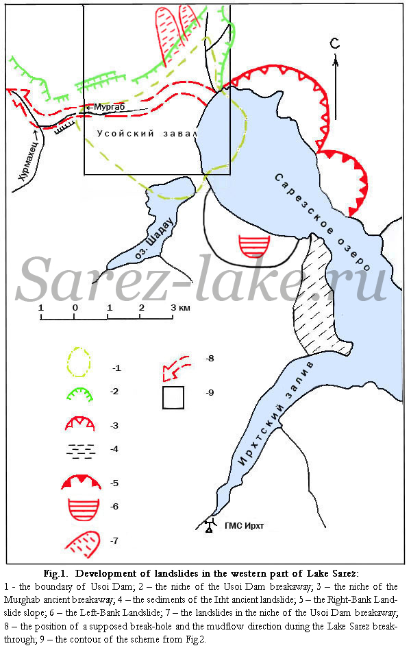
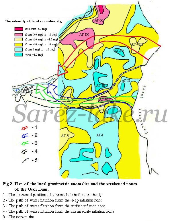
These investigations included: engineering-geological survey, geophysical works and stationary geodetic measurements, drilling of a well, compilation of topographical maps of the lake banks and a hydrographical map of the lake-bottom relief. It has been determined by the investigations that: the area of the Lake Sarez is 80 km² the water volume in the lake varies from 16.5 to 17 km³ the maximum depth depends on the water level in the lake and varies from 480 to 490 m; the length of the slide-soil dam from the upper water stream to the downstream water is 3750 m; the width from the torn-off niche top to the left-hand basic edge – 5200 m, along the upstream – 3150 m. The vertical thickness of the collapsed sediments in central part of the dam is 500-700 m. The area of the above-water part is 9.2 km². The total area, including the under-water part – 12 km². The volume is 2.7 km². The sunken part of the dam crest exceeds the lake level by 40-50 m. This excess varies depending on seasonal variations in the lake level. The average annual water level in the lake (as averaged for a 15-year interval) increases by 0.2 m every year. Two weakened zones are revealed within the dam. There has been detected landslides: Right-Bank Landslide with a size of 1.25 km³, Left-Bank Landslide – 0.15 km³, two landslides in the niche of Usoi Dam with a total size of 0.7 km³ ( Figs.1,2).
It is established by the results of the investigations that the catastrophic flood may be caused by the following reasons:
- – presence of the Right-Bank Landslide (discovered in 1967), collapse of which into the lake can cause a water inrush over the sunken part of the dam and break a pass through it;
– collapse of the Left-Bank Landslide (1975) will also lead to water overflow and form a pass through the dam;;
– colmatage process (hole clogging) in the dam top slope, discovered in 1977, causes a constant annual rise of water level in the Lake Sarez and can lead to washout of the northern weakened zone;
– fall-down of two weakened rock areas (revealed in 1988) with a total mass of 0.7 km³ onto the sunken part of the dam in its niche from the height of 1500-2000 m may lead to hardly predictible consequences;
– seismic action of an earthquake or collapse of the landslides in the Usoi Dam niche may close the cracks, along which water from the Lake Sarez flows through the dam, and cause a catastrophically quick rise the lake level, which will also lead to washout of the northern weakened zone.
The scenario of a possible catastrophe can be different. But most likely it will happen in this region due to a strong earthquake. Therefore, to predict its exact time is impossible. A catastrophic mudflow will move along the valleys of the Bartang, Pianj and Amu-Darya Rivers. According to the data of the Ministry of Emergency of Tajikistan, about 5 million people live in the dangerous zone. The highest number of victims will be on the territory of Afghanistan and Tajikistan; the maximum damage will be brought to Turkmenia and Uzbekistan.
In 2001-2006 the Tadjik Institute for Seismology and Antiseismic Construction of Tajik Academy of Sciences (TISSC AN RT) with the cooperation with the Swiss Company “STUCKY” carried out new investigations in the Lake Sarez area within the World Bank Project. The investigations included visual examination of Usoi Dam and the lake shores, and an attempt to generalize the data of the past years. The participants of these investigations did not manage to obtain any new factual information on the problem under study. Their results are reported in the publications [ 8, 9].
Development of measures on providing safety
The Sarez problem was discussed by the Government of Soviet Union. The Council of Ministers of the USSR on March 27, 1975 accepted the Resolution No. 678r “On preparation of a complex of measures on prevention of water breach from the Lake Sarez and possible usage of its water resources for irrigation and hydro-power”.
Since 1968 to 1988 the Companies “Soyuzvodkhoz”, “Soyuzgiprovodkhoz” and “Gidroprojekt” had developed the following variants of projects on providing safety:
- - build-up of Usoi Dam to such a height, which would prevent water overflow during possible collapse of the Right-Bank Landslide;
– lowering of the lake level along an open canal in the sunken part of the dam;
– lowering of the lake water level with the aid of syphons ;
– construction of a buffer dike on the Bartang River at 80 km downward Usoi Dam;
– lowering of water level in the lake by means of a floating pump station, provided with electrical energy from the hydro-electrical plant located in the dam downstream;
– lowering of water level in the lake to a depth of 100-150 m by means of a system of tunnels in the left-hand wall of the valley.
In 1988 “Gosplan” of the USSR fulfilled expertise of these projects; none of them was considered to be realistic for different reasons. All the above-listed variants had a common disadvantage – they were highly expensive and labour-consuming. Besides, no any special investigations, that would substantiate each variant, were carried out. Judging from the results of the studying works of that period, the real geological conditions for construction works in mountainous areas turned out to be more complicated than expected by the authors of the projects. That meant that in order to take final decisions, investigations should be continued.
At the present time, the possibilities of route, aerovisual and aerocosmic engineering-geological investigations in this region are actually exhausted. To carry out a large amount of mining and drilling works in mountainous conditions without availability of motor-car roads is very difficult and expensive. Therefore, at the next phase of investigations a serious attention should be paid to ahead-performing engineering-geophysical works, whereas drilling and mining works should be carried out only for checking the results of the geophysical works. At the first phase it would be urgently necessary to perform seismic survey, gravimetric, magnetic and electrical survey, exploratory seismological investigations for solution of the following four top-priority tasks:
- - to study the structure and strength properties of the northern and central weakened zones of Usoi Dam;
- to trace the water seepage ways in plane and detect places of water inflow in the dam upstream, to study the dam upper slope and water seepage regime;
– to study the structure of the underwater part of the Right-Bank sliding slope, to reveal and map the hidden cracks and ruptures, zones of compression ant extension, to determine strength and dynamic properties of sliding sediments;
– to investigate the deep structure of the western part of the Lake Sarez, to monitor and predict a seismic hazard of seismic events connected with a lowering of the lake’s water level.
The second phase should include checking of the results of geophysical investigations through borehole drilling and geophysical works in the boreholes; repeated treatment of the data of past years using modern computer technologies; calculation of the sliding slope stability at a seismic intensity up to 9M.
The above-listed tasks are key ones. Without solution of them it is quite impossible to develop really substantiated projects on safe state of the Lake Sarez. Thus, development of substantiated engineering projects requires complicated expensive investigations with the use of up-to-date equipment and devices.
There are prospects that, after the above-mentioned investigations are performed, it will be possible to develop measures on achieving the safe state of the Lake Sarez. These measures should include liquidation of unstable sliding areas on the lake banks [10]. The technique for liquidation is developed and patented [11]. It is quite clear already now that the cost of the measures on the lake safe state will require several billions of USA dollars. As long ago as in 1933, the hydraulic engineer N.A. Karaulov suggested a scheme of construction of a hydro-power plant on the Lake Sarez. After the Lake Sarez safe state will be achieved, it is possible to construct there a hydro-power plant with a capacity of 300-400 Mvt, and on the Bartang River – a few small hydro-power plants. The proposed Sarez hydro-power plant will regulate the lake discharge in an energetic regime. But a hazard of water breakthrough prevents to start construction of hydro-power plants on the Lake Sarez and Bartang and Pianj Rivers.
Water level lowering in Lake Sarez by means of intensifying filtration
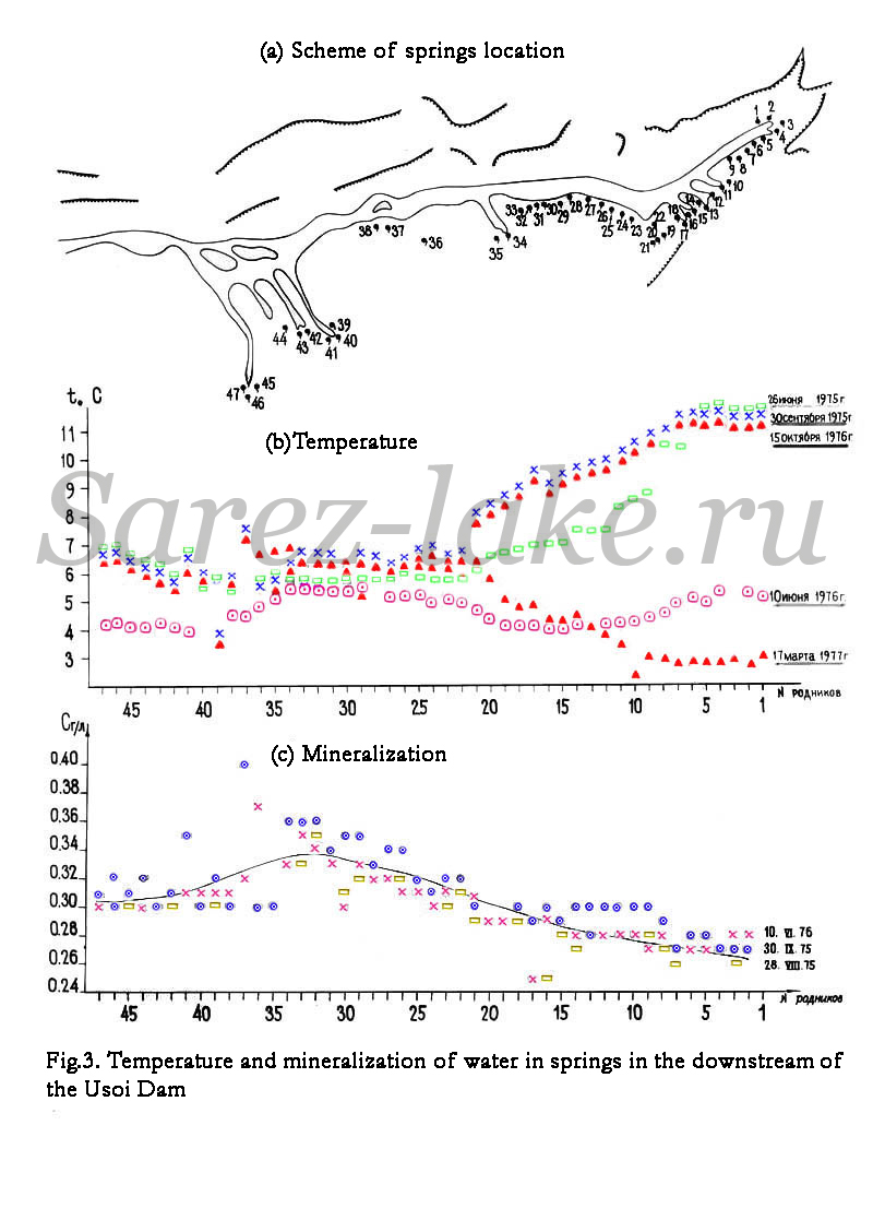
Water from the Lake Sarez moves along the hidden filtrating passes through the Usoi Dam sediments and discharges in the form of springs formed in the canyons of the dam downstream with a length of 2 km and a depth of 30 to 35 m. There were carried out the regime measurements of water temperature and mineralization in the springs (Fig.3). According the results of these measurements, three groups of springs were distinguished. The first among them, located in the head part of canyons, is connected with the surface zone of inflow, because the water temperature in these springs varies depending on a season of the year. The second group is connected with the deep zone of water inflow. The water temperature in the springs of this group is constant and actually does not depend on the time of the year, and the water mineralization is higher than in the first group. Presence of the deep filtration zone is confirmed by the dynamics of changes in the hydrological parameters of the Lake Sarez. Thus, the influence of the deep zone smoothes out the variations in the water temperature in the Barchadiv Town area. In summer the temperature is lower than on the surface of the Lake Sarez, and in winter it is higher. The third group of springs is located in the bottom part of the canyon. It is connected with the zone of water inflow, which has by vertical an intermediate position between the surface and deep zones.
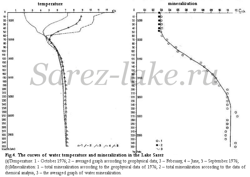
In the lakes of Sarez and Shadau there were fulfilled highly-precise measurements of water temperature and mineralization using special equipment (Fig.4). The measurements have shown that in the western part of the Lake Sarez these parameters change with depth. But at the similar depth they stay constant within the measurement error, i.e. they actually do not change in plane. Depending on a season, the water temperature in the top layer varies from 0 to 15°C. The range of seasonal changes of the temperature considerably decreases with depth. At a depth of 70 m the temperature actually does not depend on a season and is equal to 5.1°C. Within a depth interval of 70 to over 250 m it is gradually increasing and reaches 7.15°C, which stays constant up to the bottom of the lake. According to the calculations, this value agrees, within a high accuracy, with the average annual multi-year temperature of the water flowing into the lake per a unit of the volume. The water mineralization at a depth of 0 to 50 m is actually constant and equal during the measurements to 280 mg/l. Beneath this depth it gradually increases and reaches at a depth of over 250 m 1130 to 1150 mg/l. The maximum water mineralization in the springs in the downstream is 360 mg/l.
Taking this fact one can state that the lower boundary of the zone of water inflow in the dam upstream is at a depth of 80 – 90 m. below this level in the Lake Sarez there is also a stagnant zone with an increased water mineralization.
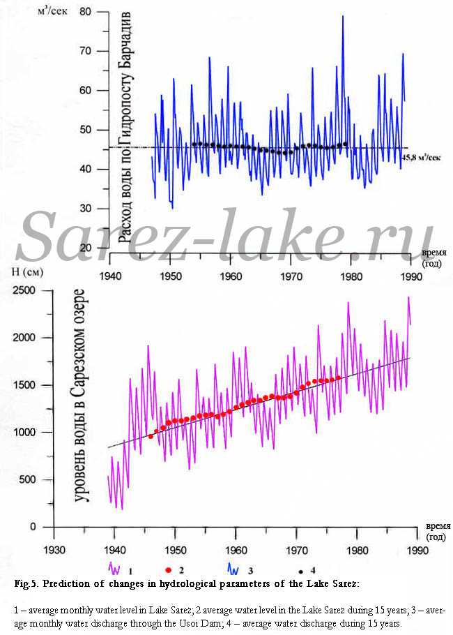
In 1939 stationary hydrological observations were started at the HMS Irht. In the lake bay of the same name a hydropost (HP) was organized, where there were being carried out daily measurements of the lake level with the aid of water-measuring poles. 17 km downward the Lake Sarez on the Murghab River, at the same time with Irht HMS the Hydropost Barchadiv was established for daily measurements of water discharge [12]. These measurements provided the possibility to obtain for a period since 1939 to 1988 the curves of average monthly water levels of the Lake Sarez and average monthly discharges of water filtrating through Usoi Dam (Fig.5).
In order to exclude an influence of seasonal variations and to verify the prediction of changes in the lake table and water discharge, the calculations of average values of these parameters were made for 15 years. The obtained graph of the average (for 15 years) lake levels is within a high accuracy approximated by a sloped line. Within a period since 1946 to 1980 the averaged lake level was increasing daily by 0.20 m. Within a period since 1976 to 2006 the averaged lake level increased by 6 m. The maximum levels during floods exceed the averaged level by 7-8 m, whereas in the low water period it is lower than the averaged level by 4-5 m.
The similar graph of the averaged water discharges for the HP Barchadiv is approximated by a horizontal line. This indicates that in spite of the constant lake level rise, the discharge of water, flowing through the dam, has no tendency to change. During the entire observation period it is equal to 45.85 m³/sec, i.e. the averaged value actually does not change.
Judging from the available historical data, it can be concluded that stabilization of the water level started in 1926 when the lake level was lower by 50 m than the present-day one.
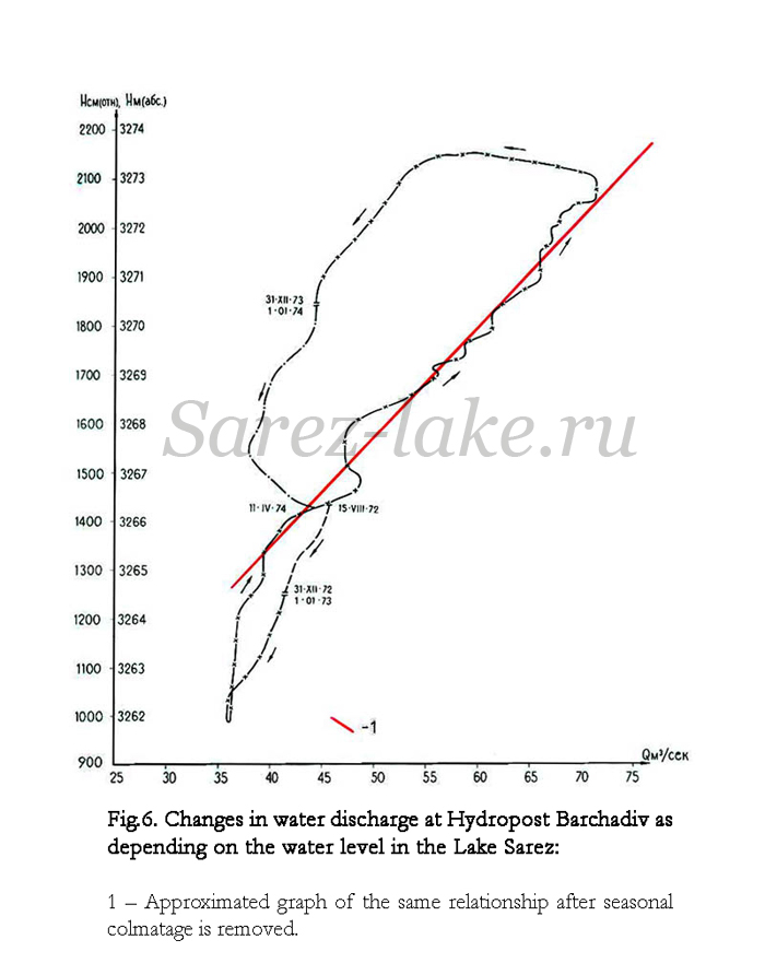
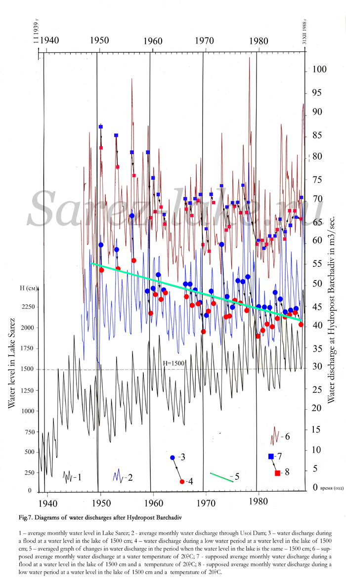
In 1977 a very strange dependence was first revealed between the water level in the Lake Sarez and water discharge at HP Barchadiv (Fig.6). In the beginning of a flood, with a rise of the lake level the water discharge increases. But it begins decreasing when the maximum lake level is achieved. With intensification of the flood and with consequent decrease in the lake level, the water discharge rates are different at the same lake levels. The difference in water rates at the high but similar water levels reaches 20 m³/sec. The similar loop-shaped relationship is observed annually. At the same level only the amplitude of water levels and difference in water discharge rates change. Fig.7 shows the water discharge rates at the same lake level equal to 1500 cm obtained by the Irht water-measuring pole. For the given lake level the above-described relationship is repeated many times. During a period since 1950 to 1988 the water discharge rate (through Usoi Dam at a lake level of 1500 cm) decreased annually by 0.33 m³/sec.
Analysis of the hydrological data shows that on the dam upper stream a constant colmatage process takes place, and for this reason the lake level continuously increases. Alongside this constant process, there is a seasonal colmatage, which causes a change in water discharge rate at the same lake level during intensifying flood and decreasing the lake level. The seasonal colmatage also promotes an increase of the lake level.
In 1977 the report on geophysical investigations of Usoi Dam presented a simple and cheap technique to decrease the water level in The Lake Sarez. The essence of the technique was as follows. The multi-year average annual water discharge through Usoi Dam is 45.85 m³/sec. The maximum water discharge during a flood is 80 to 90 m³/sec. If to intensify the hydraulic linkage of the upstream with filtration passes so, that the latter would constantly transmit maximum water amounts, the water level in the lake will decrease naturally by 50 m.
Several variants were suggested how to implement this idea. In order to select the most optimal variant, additional investigations are required. Here, we discuss only two variants that are protected by patents.
The first one. The dam body contain lateral cracks, which divide the dam sediments into blocks. Through a part of these crocks the water moves through the dam. But there are cracks which do not participate in this process. Some of these cracks were formed before the landslide, the other – during its direct and reverse displacement. On the top slope of the dam the cracks’outlets are completely or partly closed by collapsed or mud sediments. The latter prevent water penetration into the cracks. For decrease of the water level in the lake, it is proposed to carry out a detailed mapping of these cracks with the aid of geophysical investigations and clearing of the crack outlets on the top slope by means of mining and explosive works. Such clearing will increase the water discharge through the dam and, hence, lead to lowering of the lake level [13].
The second variant suggests with the aid of an electrical action to decrease colmatage of sediments on the dam-top slope. This technique is based on using the phenomenon of electrical osmosis. Such techniques are used presently to intensify oil and water inflow to boreholes. Electrical action will lead to an increase of water discharge through the dam and cause a decrease in the lake level [14].
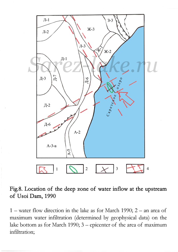
In March-April 1990 geophysical measurements were carried out from the lake ice in the bank part of Usoi Dam (Fig.8). The measurements revealed on the lake bottom an area of intensive water inflow into the dam sediments. This area is located in the place where the surface of reverse displacement of the Usoi Dam blocks is crossed with the inter-block sink. The revealed area approximately coincides with the area of intensive water inflow, which was discovered by the expedition of O.K.Lange in 1926 [15]. Therefore, for implementation of this idea the cracks’ clearing should be started first just in this area.
Conclusions
The cost of traditional measures on bringing the Lake Sarez into completely safe state is 2-3 billion US dollars. Realization of these measures requires 15 to 20 years. At the current economic situation which exists now in Tajikistan, to start investigations, development and implementation of such measures is impossible in the visible future. Lowering of the Lake Sarez level by 50 m by means of intensifying water filtration through the dam will considerably reduce a risk of catastrophic flood. The cost of this technique will amount to 20-30 million US dollars and the time of realization will be 5-6 years. American geologists Robert Shuster and Donald Alford, referring to the authors of the given paper, consider that intensifying of the filtration is the simplest and cheapest way of providing the safety of the Lake Sarez [16] .
References
1. I.A. Preobrazhensky. Usoi Dam. Materials on General and Applied Geology. V14, 1920, 21 p.
2. А.M. Lekhatinov, A.I.Sheko. To prediction of exogenic geological processes on the Usoi landslide and adjacent banks of Lake Sarez – http://www.nikz.da.ru/
3. Yu.M. Kazakov. Usoi blocking and Right Bank slope. Some results of engineering-geological investigations carried out in 1981-1992 – http://www.nikz.da.ru/
4. L.L. Kozlovsky. A complex of constructions for lowering the water level in Lake Sarez – http://www.nikz.da.ru/
5. L.P. Papyrin. Geophysical investigations on Usoi Dam (1975-1977) – http://www.nikz.da.ru/
6. L.P.Papyrin. Sarez catastrophe: a geophysical prediction – http://sarez.ferghana.ru/papyrin.html
7. V.S. Fedorenko. On possible consequences of collapse of large landslide into Lake Sarez. http://www.nikz.da.ru/
8. L.P. Papyrin. Myths on Lake Sarez breakthrough risk mitigation and reality http://www.ferghana.ru/article.php?id=5168
9. Leonid Papyrin: “Myths on Lake Sarez risk mitigation and realities”. http://enews.ferghana.ru/article.php?id=2079&print=1&PHPSESSID=f221277e0b802c371c5fef5a690c5244
10. L.P. Papyrin. Right Bank Landslide – http://sarez.ferghana.ru/papyrin2.html
11. L.P. Papyrin. A technique of decreasing the height and wave energy in a deep basin during collapse of a slide rock massif into it. EURASIAN PATENT No. 002565. Issued on 27 July 2002.
12. Informational materials of the Hydrometeorological Survey of the Republic of Tajikistan.
13. G.P.Postoev, L.P. Papyrin. A technique of water level lowering in a mountainous dammed lake. PATENT of the USSR No. 177499 from 22 June 1992.
14. L.P. Papyrin. A technique of stabilization and water level lowering in a mountainous dammed lake. EURASIAN PATENT No. 003627. Issued on 28 August 2003.
15. O.K.Lange. Expedition for examination of Usoi Dam and Lake Sarez. National Economy of Middle Asia J. No.10, Tashkent, 1926, pp.76-79.
16. ROBERT L. SCHUSTER and DONALD ALFORD: “ Usoi Landslide Dam and Lake Sarez, Pamir Mountains, Tajikistan.”. Environmental and Engineering Geoscience; May 2004; v. 10; no. 2; p. 151-168; DOI: 10.2113/10.2.151
http://eeg.geoscienceworld.org/cgi/content/abstract/10/2/151